The ultimate guide to exploring Mount Viso in Italy: Itineraries, tips and tour of Mount Viso
Discover Mount Rosa Italy, its itineraries and all our advice. Prepare for your adventure!

At 4,634 metres, Monte Rosa dominates the eastern part of the Pennine Alps and fascinates hikers and mountaineers alike. This monumental massif, shared by Italy and Switzerland, is one of the most emblematic in the Alps. On the Italian side, it stretches across the Aosta Valley and Piedmont; on the Swiss side, it overlooks the Valais. Its majestic features, made up of vast glaciers and elegant ridges, give it a silhouette that is instantly recognisable.
Its unique geographical position creates a network of deep valleys, glacial cirques and spectacular panoramas. Monte Rosa also occupies an important place in Alpine history: mentioned in the earliest accounts by explorers, it appears in the archives of early mountaineering and on the old transalpine routes linking the trading valleys. More than just a mountain range, it is a geographical and cultural landmark, inspiring generations of travellers, mountaineers and naturalists.
In this article, we tell you all about this impressive massif: how to get there, how to discover it in the best conditions, and how to prepare yourself.
Getting to Monte Rosa: how to get there and the best starting points
Despite its altitude and glacial expanse, Monte Rosa is accessible from a number of valleys in Italy and Switzerland. Situated in the heart of the Pennine Alps, it is a major attraction for high-mountain enthusiasts.
Access on the Italian side: key villages and main valleys
On the Italian side, the valleys of Gressoney, Ayas and Alagna (Val Sesia) are the main gateways.
-
Gressoney-La-Trinité, in the Lys valley, gives access to the Mountain hut Gnifetti and the Mantova hut, essential bases for the climbs.
-
Champoluc, in the Ayas valley, provides access to the Mountain hut and the routes to the western summits.
-
Alagna Valsesia, a mecca for Italian mountaineers, provides access to the southern slopes and the long glaciers of the massif.
These towns can be reached from Turin or Milan by regional buses and seasonal shuttles.
Access from Switzerland: crossing points and recommendations
From Switzerland, the most common route is via Zermatt, the iconic Valais village linked by train via Visp. From there, the Petit Cervin cable car or the Gornergrat Bahn provide easy access to the high mountains. There is also access via Saas-Fee for ski-mountaineering routes.
There is frequent public transport in summer, reducing the need to use the car in the protected areas of the Valais. It is advisable to check the lift timetables, which are very useful for optimising your approach to the glaciers.
Transport and practical advice
-
By car: you can get as far as Gressoney, Champoluc, Alagna or Täsch (before Zermatt). Some car parks charge a fee.
-
Train + bus: rail link to Pont-Saint-Martin or Verrès for the Italian valleys, then local buses; on the Swiss side, train to Zermatt via Visp.
-
Check the weather and snow conditions: some glacier access routes may be closed out of season.
To simplify logistics, the tours organised by Wildhartt offer a full escort service, ideal for taking advantage of the advice of experts in the field, whether on the Italian or Swiss side.
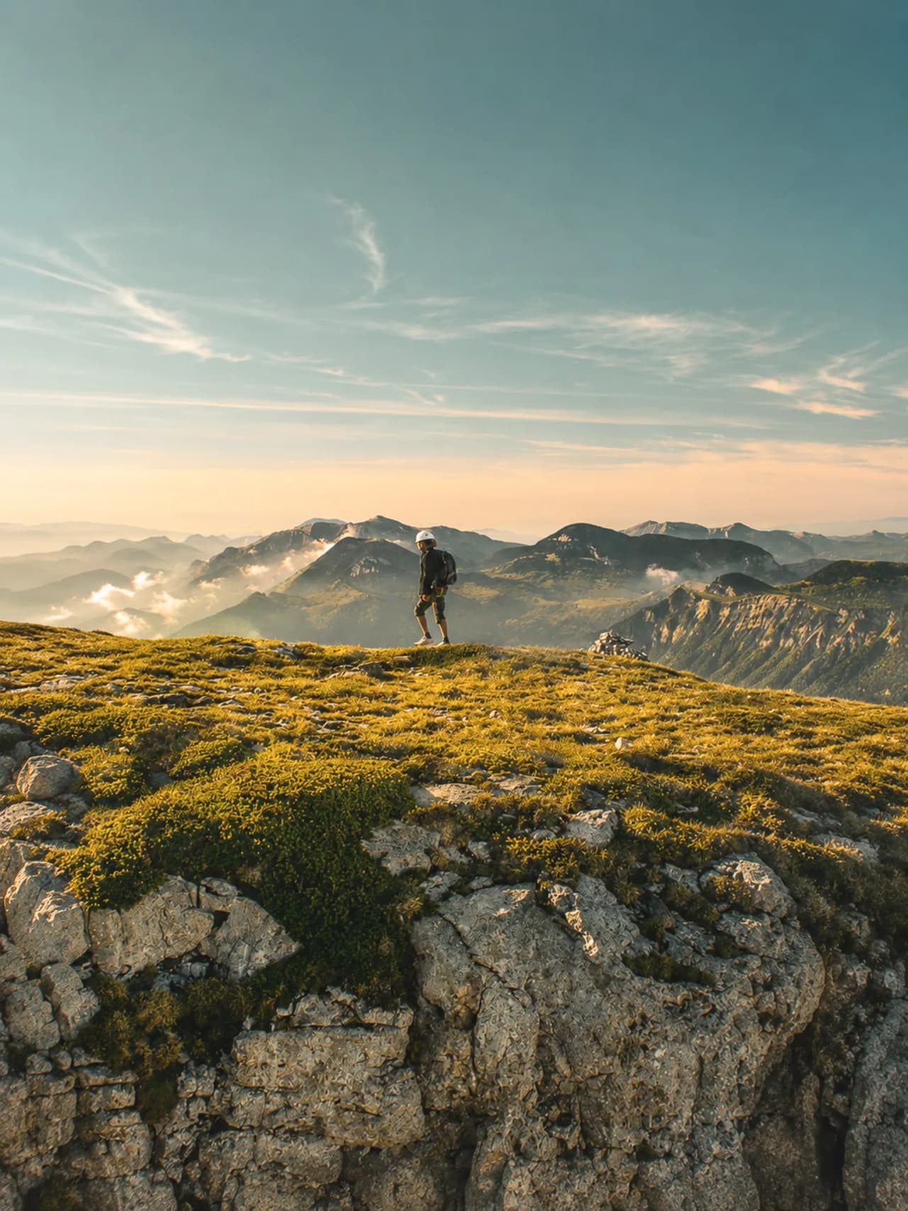
Must-do itineraries: hiking, mountaineering and Monte Rosa crossings
Around Monte Rosa, the diversity of the terrain means you can combine hiking, high mountain, glaciers and some of the most breathtaking panoramas in the Alps.
Classic hiking: immersion in the valleys of Mont Rose
The most accessible hikes start from Gressoney, Champoluc or Zermatt. The trails wind through mountain pastures, arolla forests and high-altitude lakes, while offering magnificent views of the massif's peaks - Dufourspitze, Zumstein, Parrot, Ludwigshöhe...
Hikers can reach panoramic Mountain huts such as Quintino Sella al Felik or Rifugio Gabiet, perfect for contemplating the vast expanses of glaciers.
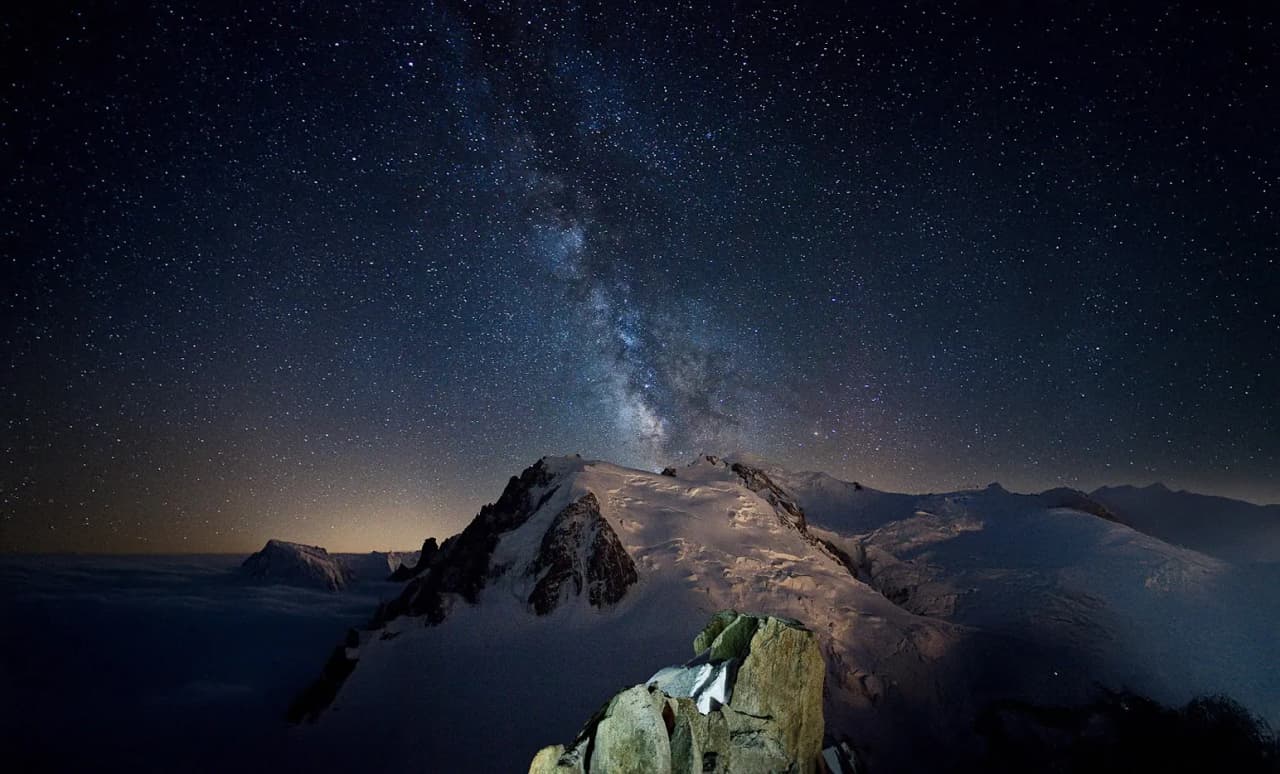
Climbing the summit: a high-altitude challenge
The ascent of Pointe Dufour (4,634 m), the highest point of Monte Rosa and Switzerland, is a demanding objective reserved for experienced mountaineers. The classic route is from the Mountain hut Monte Rosa Hütte on the Swiss side or from Gnifetti/Mantova on the Italian side to reach other accessible 4000m peaks (Signalkuppe, Zumsteinspitze...).
Progression on glacier, ridge sections and high altitude require crampons, rope, ice axe and a very good acclimatisation. Panoramic views stretch from Mont Blanc to the Matterhorn and as far as the Grisons in clear conditions.
The Mont Rose traverse: an exceptional high-altitude trek
One of the most emblematic itineraries is the Haute Route du Mont Rose, linking the Italian and Swiss valleys in several stages.
-
Duration: 3 to 5 days depending on the itinerary
-
Level: advanced hiker to beginner mountaineer, depending on the variant
-
Key huts: Mantova, Gnifetti, Margherita (Europe's highest hut at 4,554 m), Monte Rosa Hütte
-
Highlight: crossing the great glaciers (Garstelet, Lys, Grenz), total immersion in altitude
Preparing for your adventure: equipment and safety on Monte Rosa
The high-altitude environment of Mont Rose calls for serious preparation: glacial conditions, rapidly changing weather, long distances at altitude.
Essential equipment for Mont Rose
-
Sturdy mountaineering or hiking boots, suitable for crampons.
-
Layered technical clothing (3-layer system), hat, gloves, glacier goggles.
-
30-40 litre rucksack with water, food and survival blanket.
-
Headlamp with spare batteries.
-
Poles, map, GPS or offline application.
-
For mountaineering: crampons, ice axe, harness, lanyard, helmet.
Organisation and safety management
-
Anticipate acclimatisation: above 3,500 m, the effects of altitude are felt.
-
Book mountain huts (Gnifetti, Mantova, Margherita, Monte Rosa Hütte) in advance.
-
Check the weather forecast: strong winds and thunderstorms are common in summer.
-
Tell someone you know about your itinerary.
-
Start early to avoid the snow bridges, which become fragile during the day.
Fauna, flora and landscapes around Mont Rose
The slopes of Mont Rose are home to a rich biodiversity and some of the most spectacular scenery in the Alps.
Emblematic Alpine fauna
Ibex, chamois, marmots and mountain hares can regularly be seen. The skies are often crossed by golden eagles, bearded vultures and sometimes colonies of black ducks. In the most remote areas, wolves also make occasional appearances.
Botanical wealth and surprising landscapes
Depending on the altitude, you'll come across arolla forests, flower-filled alpine meadows, glacial moraines and rocks polished by the passage of glaciers. Edelweiss, gentians and anemones dot the landscape in summer. The giant glaciers - Gorner, Grenz, Lys - create a unique aesthetic, a blend of whiteness and imposing seracs.
Nature experiences and panoramas
From the high passes and glacier platforms, you can enjoy panoramic views of the entire Alps: Matterhorn, Weisshorn, Mont Blanc, Gran Paradiso... Dawn and dusk offer spectacular pinkish hues, the phenomenon behind the legend of the "rosa" in Monte Rosa.
The Wildhartt guided expeditions enhance these moments with the naturalist knowledge of the guides.
Adventurers' tips: Best times and secrets of Monte Rosa
The atmosphere of the high mountains changes with the seasons: snow, visitor numbers, opening of Mountain huts, stable weather.
Recommended periods depending on the activities
-
Mid-June to September: ideal time for trekking at altitude, when most Mountain huts are open.
-
July-August: best conditions for classic mountaineering as the glaciers stabilise.
-
Late June and mid-September/early October: quieter periods, magnificent scenery, but some mountain huts are gradually closing.
Advice from regulars
-
Leave early: better light, better glacial conditions and fewer storms.
-
Explore less-frequented variants: Monte Rosa Hütte from Riffelalp, secondary ridges around Gressoney.
-
Avoid the Italian and Swiss holiday periods if you're looking for peace and quiet.
Historical anecdotes and secrets
The massif is home to the Mountain hut Margherita, the highest in Europe, inaugurated in 1893 and dedicated to Queen Margaret of Savoy. Monte Rosa is also a key place in the history of mountaineering: its peaks were among the first 4,000 climbed during the golden age of alpinism.
The local place names - Gnifetti, Zumstein, Lyskamm - bear witness to a long tradition of mountaineering and science.
Enjoy a tailor-made holiday
Choosing a guide who is used to Mont Rose, like those at Wildhartt, means you can take advantage of the best weather windows, adapted itineraries and little anecdotes that only regulars know.
Exploring Mont Rose at the right time, armed with the right tips and with respect for the massif, guarantees an authentic adventure in the heart of the Alps.

Find your next adventure
Browse curated expeditions matching the categories of this article and start planning your next trip.
Find your dream adventure
You might also like these adventures …
Hand-picked to echo the spirit of this article.


More to discover
Keep exploring with these pages and stories picked for you.

4 reasons to climb Mont Rose via the 4000 route
Here are 4 great reasons to book Mont Rose by the 4000s today. Breathtaking views, high-altitude huts, glacier climbs and memories that will last forever

Guided mountaineering and rock climbing in Italy
Explore mountaineering and rock climbing in Italy, from Gran Paradiso and the Monte Rosa 4000ers to Finale Ligure, with UIAGM guides and hut nights.
The ultimate guide to Mont Blanc climbing
Discover everything about the Mont Blanc mountain. Learn how to prepare yourself for Mont Blanc climbing with this ultimate guide.

Top 5 must-do mountaineering courses: from Mont Viso to Chamonix with Wildhartt
Discover the best destinations for a mountaineering course: Mount Viso in Italy, Chamonix in winter, or the natural beauty of the Ecrins.

The legendary Haute Route Chamonix-Zermatt: Guide and history
Discover the legendary Chamonix Zermatt, its legend and the possibilities for exploring it.

Gran Paradiso Park Guide: Hiking, Climbing & Wilderness
Gran Paradiso Park, Italy's first national park, offers spectacular Alpine scenery. Discover its walks, wildlife and must-sees.